

How AIS improves your safety at sea
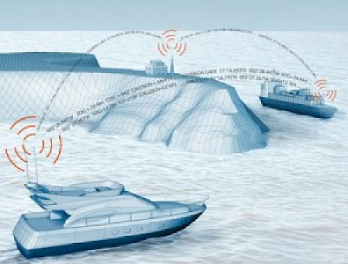
What is the benefit of Automatic Identification System (AIS)? AIS information can be used on its own, but most often the information is displayed on a vessel's chartplotter by overlaying each AIS target's physical location, heading, and other information in relation to your position and heading. Some chartplotters will even predict potential collisions and warn the operator. Since AIS information is transmitted over VHF frequencies, it is not affected by mountains or islands. Unlike radar, AIS can "see" around corners. This can be a huge safety improvement in inclement weather or when navigating the many islands and passes on BC's coast, and it is a great complement to your existing radar. Also, because AIS includes the vessel's MMSI number and name, hailing a particular ship over VHF can be simplified.
Who is AIS for? AIS is another tool that boaters can use to ensure safety on the water. AIS is not for all boaters, but if you have a chartplotter and travel along BC's coast, we recommend adding it to your boat. The recreational boater can choose from two types of AIS: an AIS receiver only, to just receive AIS information in your area, or an AIS Class B transceiver, which will also transmit your vessel's information to others.
What is AIS exactly?
AIS is a fully automated tracking system used to identify and track other vessels visually, as a method of collision avoidance. Passenger ships, such as ferries, tugboats and most large commercial vessels, have an AIS Class A transceiver (12 watts), to send and receive AIS information on VHF frequencies. Each ship transmits a unique identifier (MMSI) and its current coordinates, plus information like navigation status, speed, heading, the name and size of the vessel, and its destination. Some recreational boaters opt to transmit AIS information using a Class B transceiver (2 watts). AIS information is free; no subscription is required. All you need to take full advantage of AIS is a VHF antenna and AIS receiver (or transceiver), plus a compatible chartplotter. For an example of live AIS information visit marinetraffic.com

 $1,194.30
 $836.63


Related Content


![]()
Copyright © 2025 Pacific Yacht Systems.