FURUNO TZT19F 19" Chartplotter (touchscreen), built-in sounder
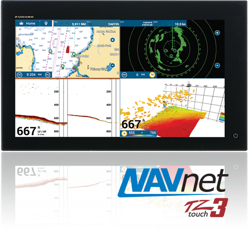
FURUNO TZT19F 19" Chartplotter (touchscreen), built-in sounder
Part #: TZT19F
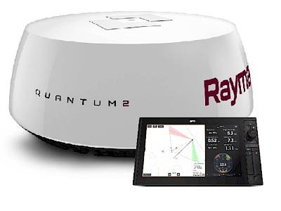
Go on a power trip with the most powerful MFD series available
Experience navigation like never before with this stunning and powerful 19” Multi Function Display. Imagine having one or multiple units on your helm, giving you a conning station that makes it look like you’re the captain of a sci-fi spaceship! Featuring a new, powerful quad-core processor for lightning-fast response time and a built-in Dual Channel 1kW TruEcho CHIRP™ & CW Fish Finder.
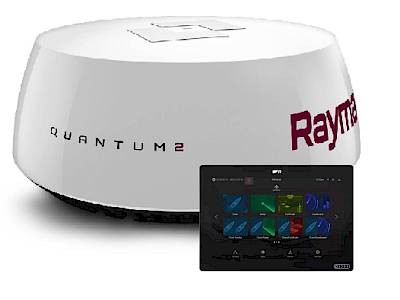
EASY to use; because finding your happy
Go on a power trip with the most powerful MFD series available
Experience navigation like never before with this stunning and powerful 19” Multi Function Display. Imagine having one or multiple units on your helm, giving you a conning station that makes it look like you’re the captain of a sci-fi spaceship! Featuring a new, powerful quad-core processor for lightning-fast response time and a built-in Dual Channel 1kW TruEcho CHIRP™ & CW Fish Finder.
EASY to use; because finding your happy place shouldn't be difficult!
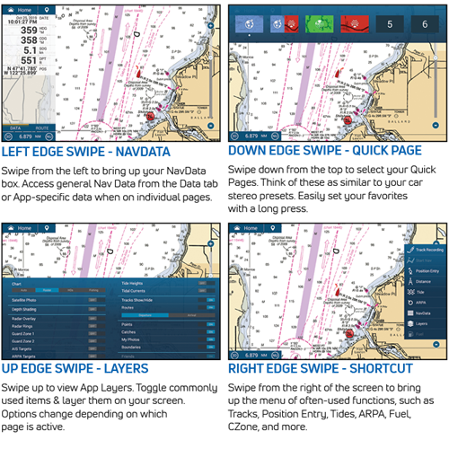
We listened to you and worked tirelessly to make TZtouch3 the easiest MFD on the market to use... bar none. With edge-swipe features and single tap menu options, you’re never more than a tap or swipe away from what you want to see or do. It’s that simple.
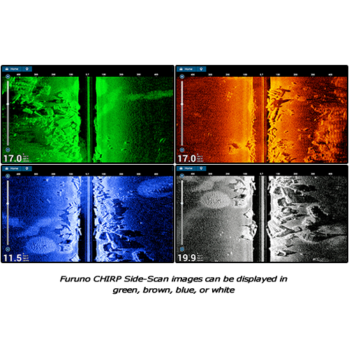
CHIRP Side-Scan at great distances on each side of the boat!
Furuno CHIRP Side-Scan provides benefits for inshore or coastal fishing that cannot be duplicated with a traditional Fish Finder, allowing you to see the presence of fish targets near piers and bridges before casting a lure or jig. With the ability to see structure and fish targets at unprecedented distances up to 750 feet, you will have the ability to scout fishing locations without scaring fish away due to engine noise or boat shadow in shallow water. You will also be able to find and fish uncharted bottom structure while mitigating the risk of grounding caused by unintentionally drifting into shallow areas.
All it takes is a free software update to Version 3.01 and connection of a CHIRP Side-Scan transducer to enable this feature in 1/4, 1/2, or full-screen presentations on NavNet TZtouch3 TZT12F, TZT16F, or TZT19F MFDs. CHIRP Side-Scan can be displayed and operated from the TZT9F, and TZT2BB when connected to a TZtouch3 network that includes a TZT12F/16F/19F.
TimeZero™ Technology is faster than ever before
TZtouch3 incorporates a fast quad-core processor so you can scroll, pan, and zoom in/out completely smooth & seamlessly. Plus, you can navigate in a 3D environment, offering you a realistic perspective and an expanded view of the area around your boat. The 3D chart perspective is perfect for planning and navigating routes.
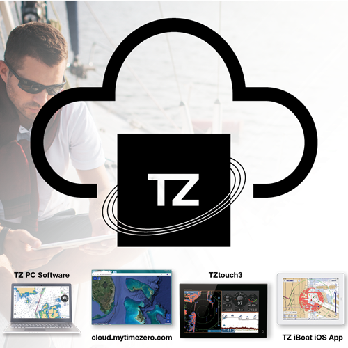
Never lose waypoints, routes or settings again with TZ Cloud
Create your routes at home using TZ Navigator, a web browser*, or TZ iBoat iOS App. Then you can retrieve them from the cloud & download to your TZtouch3. Also, create events on your MFD and retrieve them at home because the data is synchronized automatically & securely to My TimeZero. TZ Cloud also stores marks, routes, boundaries, photos, and catch data! (*Cloud.MyTimezero.com raster planning charts for US only)
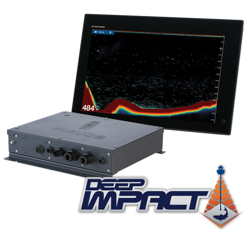
We gave you something to CHIRP about!
You spoke. We listened. And now we delivered! TZtouch3 incorporates a powerful internal 1kW TruEcho CHIRP™ Fish Finder. For many, this is the perfect Fish Finder, but for some, they need even more. So, we proudly bring you Deep Impact (DI-FFAMP), a high-powered 2kW/3kW amplifier that connects to the internal TruEcho CHIRP™ Fish Finder. But if that's not enough, Deep Impact allows you to connect a 5kW or 10kW transducer with the BT-5. Go big or go home!
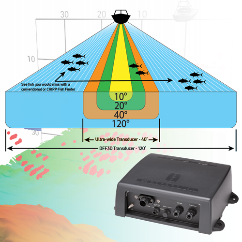
More power to see 120 degrees port-to-starboard; giving you an edge over the competition
Normal down-sounding Fish Finders have a beam angle of 40˚ or less. But with the DFF3D Multibeam Sonar, you see 120˚ port-starboard for 200m (650+ ft). Plus, with the power of the DFF3D, you can see fish directly below the boat 300m (nearly 1,000ft). When you match this with the Deep Impact TruEcho CHIRP™, you’ll have the ultimate fishing machine!
The DFF3D Multibeam Sonar operates at 165kHz, giving you fantastic depth penetration while still displaying echoes in high-resolution. Compared to a 40˚ ultra-wide transducer, you will see 3-times the area around your boat, helping you to find fish you might have otherwise missed. Plus, you can see which side of the boat they are on!
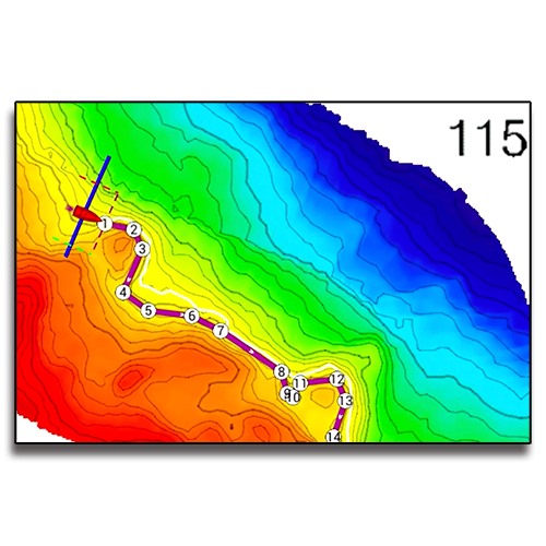
Create stunning shaded relief charts on your NavNet TZtouch3 MFD with PBG
Using the DFF3D Multibeam Sonar, PBG (Personal Bathymetric Generator) allows you to create custom high-resolution shaded relief charts of the seafloor. Bottom images are drawn with shaded relief, depth contours, and variable colors, making it easy to identify hidden structure and ridges that hold fish in a simple, easy-to-interpret presentation. Multiple color palettes are available, including the ability to show contour lines only. The area each ping covers is approximately twice the depth at the time of recording, so at a depth of 100 meters, a 200 meter-wide area is displayed and recorded to your NavNet TZtouch3 or TZtouchXL MFD or NavNet TZtouch2 TZT2BB.
Revolutionary New Features for Fishermen - Fish-It & Drift-It!
The Fish-It & Drift-It features, available only from Furuno, help you locate the correct spot to start your drift so you'll pass right over your fishing point. Tapping on a location on the chart, such as a pinnacle, wreck, charted artificial reef, or even a hot fishing spot on the Fish Finder or DFF3D Multibeam Sonar screen, creates a temporary "fishing go-to point" with dynamic range rings, a course line between the point and the boat, and a temporary track line. Now activate Drift-It, an exciting new feature that automatically creates a starting point for the vessel to drift directly over your Fish-it spot. Select a 3-minute, 5-minute, or even a 20-minute drift, navigate to the starting point, and drift to the Fish-it location in the time selected. This is a game-changer for fishermen!
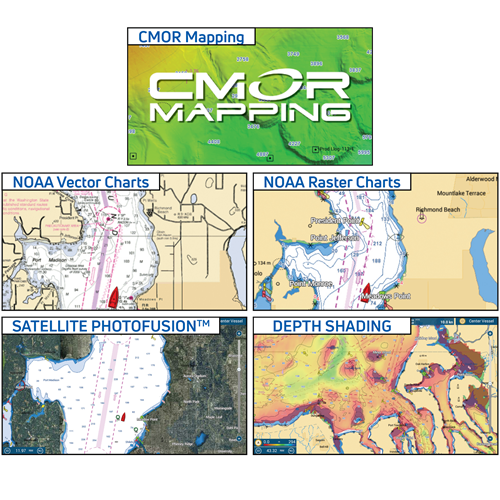
MapMedia Raster and Vector Chart Library
Freely choose the charts that fit your individual needs. Easily select either raster, vector or fishing charts, Mapmedia brings an authentic vector and raster chart library to your NavNet TZtouch3. “C-MAP” vector cartography are optional charts that can be easily unlocked. Mapmedia cartography integrates cutting edge algorithms with high resolution image processing techniques to deliver a fusion of digital navigation charts and satellite photography.
Satellite photography is included in the MapMedia raster and vector charts, simply called Satellite PhotoFusion™. Land areas (zero depth) are completely opaque, displayed as satellite photos on the chart. As the depth increases, the satellite image is merged with the chart data to provide you with added detail on seabed areas in shallow water without losing vital chart information.
And finally, CMOR’s high-resolution, shaded-relief bathymetric bottom images help navigators identify suitable locations for fishing and diving.
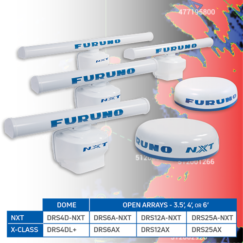
More power means better detection of all the targets around you
Are you ready to go on a Radar power trip? Nowhere else will you find Radar as powerful or with the amazing target detection of Furuno’s NXT and X-Class Radars. We juiced the power of our NXT Solid-State Doppler Radars to give you outstanding long-distance performance that matches their amazing close range ability.
Build the ultimate Navigation Suite
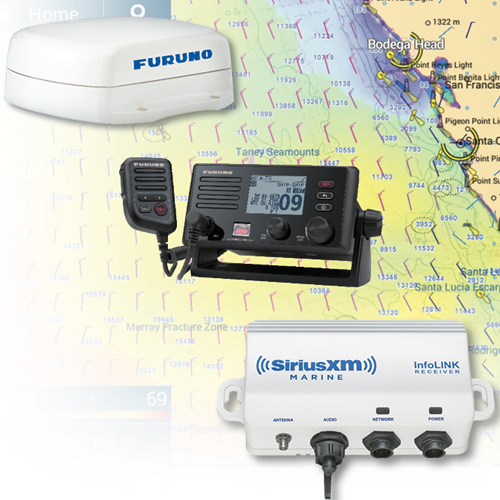
The beauty of NavNet TZtouch3 is its scalability - systems can be as big or small as you need. Add, change or remove AIS, VHF, Compass, Weather and other sensors as needed to dial in your dashboard, whether fishing, cruising or sailing.
Unlock new features and enhancements
NavNet TZtouch3 is frequently updated with new features and enhancements, including CHIRP Side-Scan capability, PBG Spot Soundings, Fish-It/Drift-It/Follow-It, and other system enhancements! Take advantage of automatic downloads of NavCenter weather information on power-up. Fishermen will love the new sunlight-viewable background color setting, and TZtouch3 Fish Finders can also take advantage of the new Color Range Expansion mode which helps differentiate fish targets from bottom structure! Take a look at the video to learn more about the most recent software update for NavNet TZtouch3.
Follow-It instantly creates a constant-depth route!
The amazing Follow-It feature leverages the power of PBG (Personal Bathymetric Generator) from your DFF3D Multibeam Sonar to instantly create a constant-depth route to navigate a specific depth contour. With just a swipe and tap, Follow-It creates a white line on the PBG chart indicating the constant depth. Tapping the line instantly transforms it to an active route, sent directly to your NavPilot Autopilot. NavPilot will follow the depth route all the way around a ridge or trough. By following specific depth contours, fishermen can keep their baits at the same level as the fish while trolling without constantly adjusting the reels. Having your bait at the correct depth is critical to catching fish in areas where tide and currents flow along structure where gamefish concentrate.
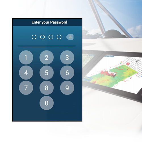
Protect your livelihood with new PIN CODE security
The new PIN CODE Lock feature allows you to require a four-digit password to be entered upon
Manufacturer: Furuno
Part #: TZT19F
Length/Depth: 4.80 in.
Width: 19.10 in.
Height: 11.70 in.
Weight: 17.20 lbs.
Screen Size (diagonal in.): 18.50
Display Resolution: 1920 x 1080
Touchscreen: Yes
Buttons: No
Pre-loaded Charts: No
Integrated GPS: No
Integrated Sonar: Yes
Local WiFi: Yes
NMEA 2000: Yes
NMEA 0183: Yes
Network Ports: 2
J1939 Ports: No
Video In Ports: 1 BNC & 1 HDMI
Video Out Ports: 1 HDMI
Supply Voltage: 12 to 24 VDC
Max Current Draw: 4.70 Amps
Waterproofing: IP56
Includes Mount: No
- Ships in 1 - 2 Weeks

 $216.99
 $152.50